Some of the trails in Zion are like big jungle gyms. They are fun and exciting, but they also require the hiker to be alert and careful. Trails like Angel's Landing and Hidden Canyon lure the hiker along uneven exposed steps with chains for balance. The Narrows hike is, at times, similar to hiking on greasy bowling balls. It also has a few small cliffs and waterfalls that become diving boards for excited children. The adventure factor is high, but the risk of injury is also high for the unknowing visitor. The number one reason to call out the Zion Search and Rescue Team is falling/slipping accidents. Don't be careless and keep your children close! The Canyon Overlook trail, Emerald Pools, and Observation Point have steep drop-offs, be aware of your surroundings, especially around the cliff edges. Suppress the urge to jump, and make good decisions. Not only are rescues in Zion labor intensive and difficult, but the rescuers are often putting their lives in danger to save you.
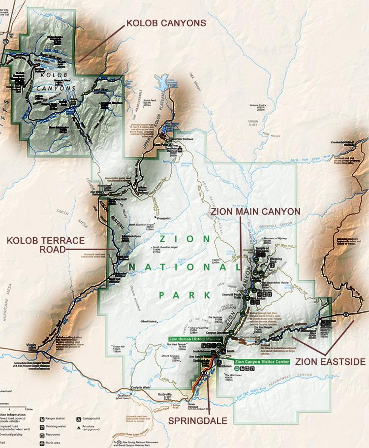
Zion Main Canyon
Hikes in Zion – Zion Canyon Hikes & Sites
Zion’s main canyon encompasses the entire scenic drive from Canyon Junction to the Temple of Sinawava. Between April and October, the scenic drive is accessible only by the free shuttle service that the park provides. The main canyon of Zion is where most visitors to Zion spend their time with good reason. Zion’s main canyon holds some of the most breathtaking yet easily accessible hikes found anywhere.
To access the main canyon jump on a shuttle bus (preferably while it is stopped) and enjoy the scenery as your shuttle driver takes you to one of the five trailhead shuttle stops listed below.
Depending on how long you have, choose from one or more of these hikes.
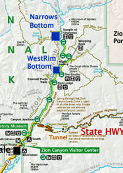
Shuttle Stops
Zion Visitor Center
Pa’rus Trail—Bikes & Dogs allowed!! This is the only trail in the park that bikes and dogs are allowed on. This trail is paved and connects the visitor center, Watchman & South Campgrounds with the Canyon Junction shuttle stop.
Watchman Trail—Though not ranked as a must do trail this little guy is still pretty neat. It has great views of the southern portion of Zion Canyon and is a great place to watch the sunset.
The Museum
No real trailheads to speak of except access to the Pa’rus trail but this stop is worthy alone for its view of the Towers of the Virgin and the West Temple. The museum hosts a short informative film about Zion and also houses a gift store. This is a great place to learn more about the fantastic natural history of Zion National Park.
Court of the Patriarchs
Court of the Patriarchs Viewpoint—Short paved trail to a viewpoint of the Three Patriarchs—Abraham, Isaac and Jacob from left to right.
Zion Lodge
Emerald Pools Trailhead—A great warm-up hike for Zion. Spectacular views and quick easy access.
Lodge—Grotto Connector Trail—A short trail for foot travel that parallels the road from the Lodge to the Grotto.
The Grotto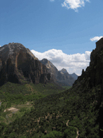
Angel’s Landing/West Rim—What are you waiting for? Click the link and check it out. This trail is not to be missed if you are up for the physical challenge and aren’t super scared of heights. This trail is also one of the terminating points of the West Rim Trail.
Kayenta Trail—This trail travels on the west side of the river and links the Angel’s Landing/West Rim Trail to the Emerald Pools trail system.
Weeping Rock
Is Hidden Canyon Trail Zion still closed?
Some trails are closed. Please do not enter closed areas. Hidden Canyon (long-term closure due to a large rockfall). Observation Point (via the East Rim Trail from Weeping Rock, long-term closure due to a large rockfall).
Weeping Rock Trail—A fantastic setting showcasing the diversity of nature found here in Zion. Short and relatively easy.
Observation Point—Hope you have been on the Stairmaster lately?. This hike rises above Angel’s Landing across the canyon to the northeast and affords the hearty with excellent vistas to the south.
Hidden Canyon—Fun and adventurous. Scrambling skills are required for deeper access of the canyon. Remember-what you go up you must come down.
East Rim Trail—A terminus of the East Rim Trail. Usually the ending point for most hikers who start near the East Entrance to the park. A personal or private shuttle is required if starting on the east side.
Big Bend
There really are no designated trails that leave from this stop but there are great views of the North Face of Angel’s Landing and the Great White Throne through the saddle between Angel’s Landing and the Organ. Some dirt paths parallel the river running north and south. If you get off here, walking on the road up to the Temple of Sinawava is pretty nice.
Temple of Sinawava
(see-nuh-wah-vah)–like guava
Riverside Walk—An excellent one-mile paved trail to the mouth of the Zion Virgin River Narrows. Seasonal wildflowers and superb hanging gardens.
The Narrows—This is the start of the bottom-up hike. The great thing about entering the Narrows from the bottom is that you can turn around anytime you like.
Eastside Scenic Drive & The Zion-Mt. Carmel Highway and Tunnel
This historic road was completed in 1930 and is considered to be one of the great engineering marvels in the history of national park road construction. Built to connect the park to points east and south it is almost as remarkable as the terrain it showcases. From the floor of Zion Canyon, you begin a dramatic climb up winding switchbacks where you will see up close and personal the Great Arch of Zion, the towering East Temple, and the aptly named Streaked Wall and Beehives. 1200 feet above the canyon floor you will enter the mile-long Zion Tunnel with its four remarkable windows, or galleries, cut straight through the red sandstone cliff. At the other end of the tunnel, you enter a wonderland of smoothly rounded sandstone hills and mesas textured by diagonal cross-bedding. These colorfully slanted lines in the rock record wind deposition of ancient sand dunes swept across this area during the age of the dinosaurs. Keep your eyes peeled for desert bighorn sheep, which can be admired from many points along this route.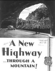
Stop and Explore!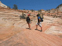
There are several pullouts along the highway where you can get out and take pictures and do some exploring away from the road. There are no maintained trails here so you simply follow the stream drainages through this maze of wildly colorful slickrock country. Make sure you stay off of fragile vegetation and thin crypto-biotic soils that help sustain life on this harsh rocky landscape. The staff of Zion Rock & Guides can help you plan a safe and fun excursion into this less-explored region of the park.
The most famous feature along this route is the Checkerboard Mesa, where there is a large pullout with an interpretive sign near the East Entrance Station. Geologists postulate that the vertical grooves etched into the face of this sandstone mesa are caused by a pronounced freezing and thawing cycle during the winter months. This effect is most notable on rock that is facing north to northeast. To test this theory out you can look directly out from the wall of the pullout towards identical sandstone facing south and southwest that, in contrast, have very smooth sides. Make sure you stop and get a photograph of this well-known icon of Zion.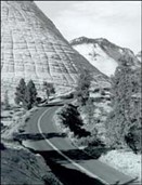
The East Rim Trail
This trail begins at a trailhead adjacent to the park's East Entrance Station. From here it is a one-way hike of nine miles to Weeping Rock, which is an excellent day hike through beautiful stands of Ponderosa pine and open mesa tops with distant vistas of canyons and plateaus with a final descent to Weeping Rock through the spectacular slot of Echo Canyon. The more ambitious can access trails leading out to viewpoints located on Deertrap and Cable Mountain with their broad panoramas of Zion Canyon below. There is a spring, which runs most of the year that makes this an attractive area for overnight backpacking. Zion Rock and Guide can help you to plan either a one-day or multiple-night stay on the wild east mesas of Zion.
Canyon Overlook
This is easily the best short hike in Zion with outstanding vistas of deep canyons and sheer cliffs, which you encounter along the entire length of this half-mile trail. After climbing up some steep stairs cut into the rock above the parking area, you will then walk along the top of a cliff ledge above Pine Creek Canyon. Here you can peer hundreds of feet down into the murky depths of this spectacular slot canyon. Don't worry there are plenty of railings and safety fences but do be careful with your footing on the loose and sandy slickrock surface of the trail. A fifteen-minute stroll to the overlook rewards the hiker with stunning views of lower Pine Creek, the switchbacks of the Zion-Mt. Carmel Hwy. and the steep walls of Zion Canyon beyond to the west. This is one of the best places to watch the sunset and also to stargaze. Take a headlamp and don't fall off the edge of a cliff on the way back to your car.
Hikes & Sites
The Kolob Terrace Road runs right up through the middle of the park from the south out of Virgin up to Lava Point. This is an excellent scenic drive with breathtaking views of a portion of the park that is rarely visited. There are also several trailheads that leave from this road into Zion National Park's backcountry. Please be aware of the Parks rules and regulations regarding hiking and camping in this area.

!!The Subway Adventure Hike requires a permit year-round as do all overnight excursions!!
Kolob Terrace Scenic Drive
The Kolob Terrace Road climbs steeply up from the town of Virgin unto the wide and forested expanse of the Kolob Terrace. Kolob is a word from the Book of Mormon used to describe the star nearest the throne of God, signifying a high and exalted place, a good name for a high plateau towering above the burning desert below. It is a paved county road that skirts back and forth through sections of central Zion National Park leading to backcountry trailheads and an overlook located at Lava Point. It eventually becomes a dirt road that continues northward all the way to the outskirts of Cedar City. The Kolob Reservoir is located 30 miles from Virgin and is a popular fishing and camping destination.

Hop Valley Trailhead
This backcountry trail leads through the red rock canyon splendor of Hop Valley and then on to the LaVerkin Creek drainages where the Kolob Arch is located. At 310 feet across it is the longest freestanding arch in the world. From this trailhead, it is a 15-mile round trip hike to the arch, a great day hike in the spring or fall when the sand of the trail is less hot and more compacted for easier walking.
There are some springs near the Kolob Arch trail junction and water is available in LaVerkin Creek year-round.
Northgate Peaks Trail
From the Wildcat Canyon Trailhead, you hike two miles across flat open meadows and beautiful stands of Ponderosa pine to a spectacular overlook revealing deep canyons and awesome naked sandstone. One of the easiest and most rewarding four-mile roundtrip hikes you'll ever take. Bring water, as this route is bone dry.
Lava Point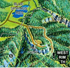
Lava Point has a primitive six-site campground (no water) and is a trailhead for both the West Rim and Wildcat Canyon Trails. There is also a scenic overlook located a short distance from the campground. From here panoramic views of the Horse Pasture Plateau, Wildcat Canyon and the distant Markagunt Plateau will take your breath away. A great place to have a picnic lunch or a barbeque, especially in summer when the heat in Zion Canyon can top 100 degrees. At 7900 feet above sea level, cool and forested Lava Point offers a pleasant quiet alternative to the hustle and bustle of the main part of the park.
Kolob Canyons
Located in the far northwest quadrant of Zion National Park these spectacular canyons can be accessed from Interstate 15 at exit 40. Located at the exit is a park service visitor's center where you can buy books and maps as well as obtain backcountry permits. If you are traveling from the main part of Zion remember to keep the seven-day visitor's pass/receipt you received when paying at the entrance gate. This pass will also cover your entrance fee into the Kolob Canyons section.
Kolob Canyons Scenic Drive
The five-mile scenic drive climbs steeply into a canyon area containing unbelievably massive orange and red sandstone cliffs. These rock layers are being actively thrust upward along the Hurricane Fault, which you will cross when driving up the hill from the visitor center into the canyon of Taylor Creek. These narrow valleys are called “finger canyons” because there are five of them and they appear to have been carved by some gigantic hand into the edge of the Kolob Terrace. The road ends at a turnaround where there is a scenic overlook, picnic tables, pit toilets and a short trail leading to a rocky prominence overlooking the canyon of Timber Creek.
Middle Fork of Taylor Creek
This is a pleasant walk along a small watercourse beneath imposing 1500-foot-tall cliffs. It ends at the Double Arch Alcove, a favorite of photographers. This spring line alcove is a quiet green oasis that is one of Zion's most serene and beautiful spots. The historic Larsen Cabin is located about halfway up the trail and is a vivid reminder of hardy pioneers living lives of remote isolation. This five-mile roundtrip hike takes about 3-4 hours and is definitely one of Zion's prettiest canyons.
Lee Pass/LaVerkin Creek Trail
This trailhead is located 3.5 miles from the Kolob Canyons Visitor's Center and is the northern terminus of Zion's backcountry trail system. From here the trail descends into LaVerkin Creek the principal drainage in this section of the park. Hiking destinations include the Kolob Arch, Beartrap Canyon, Willis Creek and Hop Valley. From here it is a 15-mile roundtrip hike to the arch, which is the largest arch in the world. It takes about 5-6 hours and is well worth the huffing and puffing required to hike back up to Lee Pass at the end. There are many backcountry campsites along this trail where water is available year-round in LaVerkin Creek. You can obtain more information from Zion Rock and Guide on the options available for a variety of backcountry trips in this area. Permits are required for all overnight trips in the Zion backcountry.
Timber Creek Overlook Trail
Starting from the end of the scenic drive this one-mile roundtrip hike leads to a rocky hilltop where extensive views to the south reveal a vast country of mesas, canyons, and distant mountains. On a clear day, you can see Mt. Trumbull in Arizona, a distance of some 100 miles. This trail is uneven and rocky so it's a good idea to wear hiking boots for comfort and safety. Don't forget your camera.
Springdale shuttle map
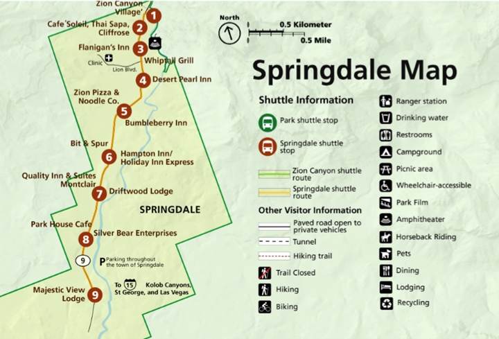
Springdale map, courtesy NPS.
IN SPRINGDALE
Springdale probably has the best public transit system of any 600-person town in the country. Free shuttles run up and down the entirety of Zion Park Boulevard (turning around at the Majestic View Inn) on a frequent and regular basis. Shuttles start just outside the walk-in entrance to the Park, next to Sol Foods and close to the Main Visitor Center. If staying at one of the Park Campgrounds, hopping on the shuttle is easy. On busy days, limited parking in Zion often means visitors are required to park in town and hop on a Town Shuttle to get to the Visitor Center and Park shuttle system.

UP CANYON AND DOWN CANYON
Both shuttle systems run North-South along the two-lane Highway 9/Zion Scenic Drive. Shuttle signs and bus drivers refer to shuttles headed either "up canyon" or "down canyon". The south end of Springdale is the END of the canyon, while the Temple of Sinawava is the furthest shuttle stop UP Canyon. Generally, head Up Canyon (shuttle stops on the road's East side) to explore the Park, reach trailheads, and find The Narrows. Head Down Canyon (shuttle stops on the road's West side) to go back to the Visitor Center or to Springdale.
Zion National Park Shuttle Map
There are 9 Stops on Zion’s Shuttle Service (18 including the Springdale Line). Generally, the bus comes every 10-15 minutes, but schedules vary by time of day and the season and can change each year. Be sure to plan ahead; which stops to take and how much time to plan for. Remember, when the last shuttle leaves the canyon you’ll be left to walk out – so plan ahead!
Zion Canyon Shuttle System Map
How to use the shuttle system
The Zion Canyon Shuttle connects the Zion Canyon Visitor Center to stops on the Zion Canyon Scenic Drive. Shuttles leave every few minutes and go either north or south. You can exit the shuttle at any open stop.
Check the map to see what to expect in the park. You may get on and off at any open shuttle stop. Most visitors start shuttle trips at the Zion Canyon Visitor Center, but if you are staying at the Zion Lodge, you can board the shuttle there. You cannot board a shuttle to go up canyon (north) at Canyon Junction.
Read our Park Information Guide to see updated information about the stops that are open or closed now.
If you drive to Zion, remember that National Park Service parking lots often fill early in the day. Paid Parking is available in the town of Springdale. If you leave your car in Springdale, you can ride the free Springdale Line shuttle to enter the park.
Learn more Traffic and Travel Tips before you arrive and tune your radio to 1610 AM for more information.
Rules of the road
Do your part to keep Zion National Park's shuttles clean. Remember:
- No eating or smoking on the bus
- Only capped bottles of water are allowed.
- Pets are not allowed on the shuttle buses.
Shuttle Narration
Listening to the Zion Canyon Shuttle Narration is a great way to learn about Zion Canyon Scenic Drive if you visit when shuttles are not running or if you want to learn more when you are not in the park.
Comments